
Australian Bush Heritage - an inspiration for the Heidelberg School of Painters
A question raised almost immediately when we talk about the NE link is simply where is it proposed to be built?
Friends of Banyule had meetings with VicRoads April 2010 to gain an understanding of the alignment and location of the freeway. No information was available on either the alignment or funding structures and we were told that the project is being scoped. We left the meeting without any answers and the distinct feeling that the organisation was being evasive on all of our concerns on the project.
Currently there are a couple of maps that give some indication of the proposed route – one is the GHD report commissioned by the government in 2007 showing a connection between the end of the Western Ring Road and the Eastern Freeway through Greensborough, Watsonia, Viewbank, Rosanna and Bulleen. The other was obtained via ‘Freedom of Information’ and there is also the 2010 Melways Map showing a similar alignment. See Friends of Banyule’s North East Link web page for map details
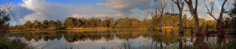
The particular concerns that galvanise Friends of Banyule are the Banyule Flats, Warringal Swamplands and Bolin Bolin Billabong, an 81 hectare area, which forms part of the ancient floodplains along the Yarra River located within the metropolitan suburbs of Heidelberg, Viewbank, Rosanna and Bulleen.
Banyule Flats and Warringal Swamplands are lowland riverine flood plains that are among the most threatened landscapes in Victoria. Banyule Swamp is the most intact and biologically significant shallow freshwater marsh in the Lower Yarra. Both are key wetland areas in maintaining the viability of populations of water birds and wetland ecosystems in the Lower Yarra. They contain a number of rare, vulnerable and threatened fauna, 23 species of water birds, 125 species of native birds, 11 species of native mammals and 4 bat species.
The Victorian government has been planning to build a freeway right through the middle of Banyule Flats and Warringal Swamplands. The newly elected Liberal government has not yet confirmed whether it will continue on the same path and refuse to consider public transport solutions for Banyule, a municipality which is chronically under-serviced.
This freeway, the so-called North East Link, will not ease congestion but will destroy one of the most precious environmental and historical assets in the City of Banyule: the birthplace of the iconic Heidelberg School of Painting, the first internationally recognised Australian Art Movement.
In 2002, the Victorian MP for Ivanhoe, Craig Langdon, got up in front of 1000 residents at Banyule Town Hall and swore there would be no freeway through Heidelberg and Bulleen as long as he was an MP. He claimed the support of then Minister for Transport, Peter Batchelor, who declared in Parliament: ‘‘There is a very wrong suggestion that the Government has a proposal to build a freeway through the Yarra Flats … It is a tragic and sleazy attempt by a conspiracy of the deluded to try to frighten people living and working in this area … these people will have no basis for making the suggestions in the future.”
If this proposed $6 billion project were to go ahead, we will have all been betrayed by the Government.
Ten years ago, government spokesmen were saying that building more and more freeways cannot go on – but it is. State and Federal governments have facilitated more road freight and less by rail, while promising to do the opposite. We need to continue to remind our State government that the Yarra Valley is not theirs to turn into an asphalt-covered tarmac, and that 90 per cent of traffic on roads is passenger traffic looking for the necessary public transport alternative. Superior public transport, cycling and walking options to overcome the car dependency now dominant in Banyule and surrounding municipalities is what is required.
The North East Link would go through the home of the Heidelberg School of painters and an invaluable conservation area. It will also cut a swathe through Heide, home of the Australian Modernists, with little concern for our cultural history or the environment.
It would also dismiss the thousands of Melburnians who use the area for passive and active recreation, including the members of many sporting clubs.
Yes, there is a missing link. It’s called Public Transport and sensible planning decisions. It is the responsibility of the major parties to provide public policy for the necessary public transport alternatives to protect our valuable heritage for this and future generations.
In August 2010 after a contest in the Courts, the government revealed to Greg Barber MLC under Freedom of Information (FOI) that it had submitted a bid for funding to Infrastructure Australia. The freeway’s route shown in the documentation is identical to one outlined in government planning documents from 2001, which the government denied existed – until they were revealed in the court case and FOI response.
Infrastructure Australia knocked the proposal back on several grounds but the former Labor government was looking for a public private partnership to build and operate the freeway.
Friends of Banyule are suspicious of the fact that the proposed freeway is projected by the Victorian government as a freight route to take trucks off busy suburban streets. Much of the traffic we endure is locally generated and only a small proportion is cross-town. Most of it is cars and a relatively small proportion are long distance heavy trucks.
The enduring historical pattern with freeway development in Melbourne since the 1960’s has been greater car dependency. More and more household income gets poured into transport as a result. One freeway gets filled up and then the government decides to build another one. Haven’t they heard of climate change?
Frankly, we hear far too much about so-called ‘missing links’ and nowhere near enough about Public Transport Networks. The nearest linking bus service to Montmorency train station is 300 metres away. Other stations have none. Poor linking bus services are a major reason why train use in Melbourne generally and Banyule in particular is sub-optimal. There is no more money in the Victorian Transport Plan for added SmartBus and local bus services. However, there is $6 billion (and counting) earmarked for a freeway. No-one in government even mentions the much needed duplication of the Hurstbridge railway line.
The former Victorian Brumby government with the support of the Liberal Opposition signed off on the westward and northward expansion of the Urban Growth Boundary (UGB). (Please note, that since going to ‘press’ the incumbent Ballieu Liberal Government has rescinded the UBG policy and is reviewing it). The tardy development of heavy rail services especially northward on the Epping line threaten to bring more road traffic into Banyule – North-East Link or no North-East Link.
The Liberal government is yet to advise on plans for orbital passenger rail in the north and the west in the wake of the expansion of the Urban Growth Boundary. We know that the major weakness in the eastern and southern suburbs is the lack of high-capacity orbital Public Transport services. The SmartBuses are a second best retrofit because no land was retained for rail reservations by successive and very thoughtless state governments. Such is not the case in the north and the west. The land is there but where is the government commitment to orbital heavy rail for passenger services?
We have been very badly let down. In 2001 the then transport minister, Peter Batchelor, who declared in Parliament: QUOTE ”There is a very wrong suggestion that the Government has a proposal to build a freeway through the Yarra Flats … It is a tragic and sleazy attempt by a conspiracy of the deluded to try to frighten people living and working in this area … these people will have no basis for making the suggestions in the future.”


We live in a larger more populated city and metropolis than we did before. As we need better public transport we also need better freeways so we can take the pressure away from areas like the Heidelberg cutting and Fitzsimons lane..We must go forward as a community together and that includes people with polarised views on things. Healthy debate should be just that, but compromise will always be the winner when good planning leads to things getting done hopefully for the better rather than living in a time warp.. I live in Banyule and I want this freeway before I die. I also enjoy using public transport and can t wait until I can be proud of both.
Bike tracks , recreation reserves and the environment in general should be high on the agenda in search of the balance we need to find. I want to love this whole city as much as I did before and I am not afraid of change like some of you are. Some of you may have vested interests as I think was the case in the 60’s when Dick Hamer caved in to the property owners in East Ivanhoe and as a result the land in Banyule was subdivided. I sense this hypocracy still thrives. I just hope the bigger picture avails this time.
Warwick Archer
Dear Warwick
If you don’t look at the wider picture of the transport system as a whole, rather than the building of another freeway as somehow a magic bullet responding to a particular problem (eg Rosanna Road/ Hoddle St etc), then there will always be another freeway to build. You’ll always have another “missing link”, to join the dots on the map. What is required is an integrated system, which takes into account all the elements of an overall transport system in a holistic way, including road, rail, cycling, pedestrian, inter-connectivity and land use, on a planned, forward looking basis.
Otherwise, you end up with “induced traffic” creating more congestion & more gridlock, such as Los Angeles, Beijing or Bangkok, where pollution has reached dangerous levels requiring urgent measures now being introduced. Continuously adding to the road and freeway network without, commensurate improvements to public transport with capacity of mass transit systems such as London, Amsterdam, Zurich etc, to move large numbers of people around major cities in an efficient and effective manner, with minimal pollution and impact on the environment, we simply build in more problems for future generations.
Building freeways through parks and reservations is a very inefficient method of land use, in an age of increasing pollution where planners are talking of the “green city” and the importance of public parkland and tree canopy to mitigate the” heat island effect” of increasing urban development and climate change. The Eastern Freeway was designed with a potential future rail reserve down the centre. This is the proposed route for the Doncaster Rail Line, similar to the Mandurah Line in Perth. This presently available land, will be lost if East/West Link proceeds.
Considering that the major freeway tunnel solution (eg; North East Link) would not be in operation till 2020 or beyond (or a decade more if East/West Link proceeds), you’ve still got the congestion on local arterial roads in the meantime to deal with. Traffic management measures are available to Vic Roads to alleviate this, which we have previously mentioned (including lane, time of day and speed restrictions for heavy vehicles as well as enforcement). Heavy vehicles including B doubles and other articulated vehicles are using these roads in Banyule to avoid tolls on the Tullamarine/ City Link and Monash Freeway corridor. There needs to be sufficient restrictions on these roads (which are also residential), to persuade transport operators to use the above designated heavy vehicle routes instead.
We need to plan for the long term and consider what sort of city we want in the future. If Melbourne is to retain its “Most Liveable City” mantle, then we should avoid going down the road (or the freeway) to a Los Angeles style traffic congested future. If other cities around the world can do this, then so can we!
Dennis O’Connell
President
Friends of Banyule
Dear Denis,
You do make a lot of sense and I agree with a lot of what you say.Those non magic bullets you talk about can be very expensive as well .However, having come this far with our freeway systems right or wrong , wouldn’t it be even more senseless not to finish the last link of this orbital road when it can not be denied there would be substantial benefits to the transport of freight and industry in this region , not to mention some relief to the streets of Banyule.
Warwick Archer
Warwick, the bigger picture, and indeed true progress, is seeing that oil dependency is not sustainable, and taking action to move away from it. We cannot go on using our limited peak oil reserves with such sense of abandon. We need to prioritise world class public transport, making it technologically current and attractive for all, and we need to do it now. If the rest of the developed world can see this, why can’t Australia? We are the true dinosaurs in this sense; clinging onto a naïve and no longer relevant nor realistic mid-20th century Australian Dream of entitlement and wastefulness.
World class public transport needs to be supported with better freeways but not more freeways. Multiple passenger and bus only lanes, goods vehicle curfews etc are just a few ways freeways can be improved.
Friends of Banyule members represents a diverse, age varied group of individuals. Many of us, like myself, are in our early 30’s. Many of us, also like myself, do not live in the high property priced hot spots of Banyule. We live simple and rich lives moving around and appreciating the beautiful parklands that surround us. My only vested interest for ensuring freeways do not go through these magnificent lands; respecting custodians of these sacred lands and for my future children and grandchildren to enjoy like I do.
Gretta your reply is appreciated and your comments read carefully. I would like to add to my arguments as to why we should complete our freeway system and with reference to some of your words..
1 . I would imagine the world will always want independent transport and technology and future consideration will only change it not eradicate it inspite of the looming fossil fuel debacle.. Can I ask if you have been on a Melbourne freeway recently at 6.30 am and noticed the number of utes, vans, wagons,trailers,small trucks, large trucks, vehicles with roof racks and ladders, and others on their way to a task.These tasks are the things that need to be done on a regular basis to keep a city running. I do agree we have a poor record with public transport and we need to do a lot more. I do agree we have wonderful parks and gardens but I also envisage some time into the future we can possibly have even more green and vegitation beside the way we live in cities with quieter freeways due to new technology and mono rails for public transport.
Warwick
What’s the latest on the N-E link proposal? I’m guessing that it may be more likely to go ahead in some form now that the E-W link has been stopped.
I have to admit that I don’t fully understand why a N-E link would be a bad thing for Banyule. If they tunnel under the parklands as promised, shouldn’t the environmental impact should be small?
Hi Girish, The current status is that it’s not on the current governments list of infrastructure projects. The problem with a tunnel is that there won’t ever be one because if there was it would make the NE link even more expensive than the EW link. And by now we all understand what cost benefit ratios are….cheers Marion
I love how all you short-sighted hippies disappear once you realize public transport can’t actually solve anything.
Smh
We need to build North East Link.
You cannot get trucks onto a tram or train.
But you can the people from the single occupancy commuting cars that currently take up around 95% of the traffic that currently clogs the roads. Build better PT networks for commuters and the trucks can have the 40km/h road all to themselves
This freeway must be built as a matter of urgency ! Melbourne’s present dysfunctional Freeway system represents a colossal failure of government, particularly labor governments and must & will be fixed. Its called reality!!!
Hydro-carbons are easily replaced in motor vehicles by battery power so oil dependency is simply not an argument. Personalized transport is here to stay. We are a first world country & demand first world mobility. Get used to it! This wailing for public transport & the absolute fantasy that public transport can negate the desperate need to an adequate roads network is a huge, stinking red herring. And of course a new freeway attracts lots of traffic. That’s because the present system is so totally inadequate, not that more traffic is created. That happened back in the ’80’s when every family got a car for family member over 18.
Melbourne has a population of 4M with a road system of a large county town, thanks mainly to the remarkable incompetence & neglect of the Cain labor government. That’s what happens when micro focused single issue pressure groups, whose only real issue is their own self interest, holds sway with governments.
This should be a FREEway, built above ground as the best possible cost to benefit ratio, using tax payer’s funds. START NOW!!!
Why are you here? You’re clearly not a Friend of Banyule.
“Micro focused single issue pressure groups”
You mean like the RACV?
It seems to me all the pressure comes from petrol-guzzler-lovers in Liberal-held electorates who bought a bit too far out of the city wanting to force those who bought in a green belt to accept a stinking choking freeway through their wetlands and riverlands.
In this case self-interest dovetails nicely with the broader good, things like saving a green wedge, saving wetlands, saving an area of cultural significance (heard of the Heidelberg School?) and, yes, improving public transport.
It must be exhausting running this website with fume-loving trolls posting boring rants.
Thanks for your support, Tom.
I enjoyed your slogan stereotypes – ‘petrol guzzler lovers’, ‘Liberal-held electorates’, ‘sitinking choking freeway’ ‘fume loving trolls’ Always good to start the morning with a chuckle over my cuppa…..
What about people like myself who with my wife and three kids moved into the Banyule area six years ago to become ‘friends of the Banyule area’, but have seen an ever increasing amount of traffic zipping through the back streets, flying past schools and parks and choking residential streets. The increase in just the last 24-36 months has been really noticeable. You can see this during the peak periods on the VicRoads live traffic app – more and more red and purple sections of road – leading to significantly higher localised levels of NOx, SOx, CO and particulates as well – noise too of course.
My family are regular visitors to Heide Gallery and its surrounds, I occasionally jog through the Warringal Parklands and would spend more time in Heidelberg shopping precinct if it wasn’t for the disgusting levels of traffic ever present.
Sadly we are going to leave the area in the next year or two, and one of the main reasons is traffic. Our street is a residential one (the brown thin ones on the Melway), however is becoming more and more popular with ‘rat racers’ trying to avoid Para Rd and Bolton Street. Our neighbour who has been here for 25 years never knew of an accident on our street until 3 years ago. We’ve had 3 in the past 3 years! He is very worried about the increasing traffic, and he too puts directly down to the lack of a NE link. Sure just one example, but certainly a ‘case study’ for what is happening in the NE suburbs. And sprawl through Doreen, Mernda etc. is only going to exacerbate it. Why the truck curfew? Even the head in the sand governments have identified a concern, but can only offer a few thousand dollars to put up a series of road signs!!
My parents live in the Knox area where I grew up and still visit regularly. As soon as Eastlink was built, traffic levels (anecdotally) decreased by at least a third in Stud Rd, Boronia Rd, Burwood Hwy, Springvale Rd, Bayswater Rd, Dorset Rd. On Stud Rd, traffic levels dropped so much that they could even ‘sacrifice’ a lane for a dedicated bus lane.
With Greensborough Hwy already in place from the Ring Road to Lwr Plenty Rd, and with proposed tunnels from there under the Yarra Flats area all the way to the Eastern Fwy, I fail to see where the so-called devastation to Banyule is going to come from. I concede that tunnel ventilation could be of some concern initially, but with 40 years of air dispersion modelling experience out there the appropriate locations and techniques would be employed. There have been no environmental issues with the ventilation of Melba and MM tunnels with Eastlink.
I would love to know what scientific basis FoB are using for its outright denunciation of the NE Link on the proposal that I have mentioned.
If however, the proposal was for an above ground alignment through any of the sensitive sections on the Yarra Flats/Banyule Flats areas, the shoe would be on the other foot for me.
Oh yeah did I mention I catch the train into the city to work each day!
Agreed – the Cain Government was diabolical for transport in general in Victoria. In the mid 70s we had the city loop designed, approved and construction started, as well as several tram line extensions and a new fleet of trams. The Comeng train fleet was introduced also. We had the Eastern Freeway, the West Gate Bridge/Fwy, the Tulla Fwy, the Calder Fwy, the Mulgrave and the widening of the Nepean. And then…….it all stopped in the early 80s. The train system fell apart during the 80s and became grossly inefficient. Then we had the strikes and the shutdowns. We then had band-aid solutions with their idealistic ‘no freeways’ policy where we saw the Mulgrave and SE Fwys joined by a road with traffic signals, the extension of the Eastern Fwy that was half the size of the original fwy, and its partnership with its Federal counterpart bringing a Ring Road that was beyond capacity before it was even opened. Then there was the official abandonment of the Doncaster Rail and Waverley Park branch line proposals. The list went on and on.
The NE Link is one of, if not the most critical infrastructure project in Australia. What I would like to see is the most direct (and obvious) route implemented where a quarter of the route is half constructed already! Greensborough Hwy with interchanges at Grimshaw, Watsonia and Lower Plenty Roads (running in parallel with the current G’borough Hwy). Then underground from Lower Plenty Rd to Bulleen Rd near Marcellin College, where significant acquisition of a tennis club &/or part of a golf course would be required to interchange with the Eastern. The Eastern Fwy going Eastbound would have to be widened to 5 lanes each way until Tram Road and 4 lanes until Eastlink.
The shortest option, the most environmentally sound option (the do-nothing option is not an option), and arguably the cheapest. Make it a BOOT project, where it will get built quickly and properly a la Eastlink.
The other alignment (where it swings up above Eltham North, and essentially follows the HV transmission line alignment down from Research to Ringwood) will cause massive environmental headaches, and the cost potentially three times that of the preferred Banyule option, not to mention a logistical nightmare trying to integrate the road into the ‘spaghetti’ at Ringwood.
Banyule City Council has to get its head out of the sand and endorse the so-called ‘Banyule alignment’. It will significantly improve amenity in Macleod, Rosanna, Ivanhoe, Alphington and especially in Heidelberg, which has just turned into one gigantic carpark over the past 5-6 years. And yes property prices will rise as a result, and that means (the collective rubbing of hands in the council chambers)…..more rates!
Hi Cam. Thanks for your comment. You offer reasonable, arguably more environmental routes if a road was to be built but I just can’t agree that a road needs to be built for the reasons I’ll give below. I’m a scientist myself, so I naturally see the importance in scientific evidence. Where appropriate, I’ll be following points with references for your interest.
My first issue is induced demand. It is well documented in the literature that new roads encourage increased vehicle use and distract us from the implementation of well connecting public transport:
• Litman T. Generated traffic and induced travel, implications for transport planning, Victoria
Transport Policy Institute (Canada) 28 March 2014 http://www.vtpi.org/gentraf.pdf
• Hymel KM, et al. Induced demand and rebound effects in road transport. Elsevier. Volume
44,(10),1220–1241 (2010) http://www.sciencedirect.com/science/article/pii/S0191261510000226
• Dowling, J. Auditor slams plan for road tunnel link. The Age. 16 April 2013. Retrieved 31
March 2014 from http://www.theage.com.au/victoria/auditor-slams-plan-for-road-tunnel-link-20130417-2i0lq.html#ixzz2xWM6MalN
Secondly, apart from the environmental and safety issues that increased vehicle use results in, more pollutants in the air has an immediate and detrimental effects on people, particularly those with existing respiratory problems:
• Laumbach R.J. and Kipen H.M. Respiratory health effects of air pollution: update on biomass
smoke and traffic pollution. J Allergy Clin Immunol. 39,3–11 (2012) http://www.ncbi.nlm.nih.gov/pubmed/22196520
• Bui DS, et al. Ambient wood smoke, traffic pollution and adult asthma prevalence and severity. Respirology 18(7), 1101-7 (2013) http://www.ncbi.nlm.nih.gov/pubmed/23627489
• Zhou C, et al. Modifiable exposures to air pollutants related to asthma phenotypes in the
first year of life in children of the EDEN mother-child cohort study. BMC Public Health 13, 506 (2013) http://www.ncbi.nlm.nih.gov/pmc/articles/PMC3671198/
• Lindgren A, et al. Traffic-related air pollution associated with prevalence of asthma and
copd/chronic bronchitis. A cross-sectional study in southern sweden. Int. J. Health Geogr.
8,1–15 (2009) http://www.ncbi.nlm.nih.gov/pmc/articles/PMC2649061/
• Gehring U, et al. Air pollution exposure and lung function in children: the ESCAPE Project.
Environ Health Perspect. 121(11-12),1357-64 (2013) http://www.ncbi.nlm.nih.gov/pubmed/24076757
• Migliore E, et al. Respiratory symptoms in children living near busy roads and their
relationship to vehicular traffic: results of an Italian multicenter study (SIDRIA 2) Environ
Health 14, 27 (2009) http://www.ncbi.nlm.nih.gov/pubmed/19534827
• Esposito S, et al. Possible molecular mechanisms linking air pollution and asthma in children.
BMC Pulmonary Medicine 14,31 (2014) http://www.ncbi.nlm.nih.gov/pubmed/24581224
• Unknown. Burden of disease from ambient air pollution. Public health, social and
environmental determinants of health (PHE). World Health Organisation (2014)
http://www.who.int/phe/health_topics/outdoorair/databases/AAP_BoD_results_March201
4.pdf?ua=1
Thirdly, we care about more than our own backyards and think it is unfair to just dump the issue onto others. Who wants to have a freeway built next to them? We would not wish that on anyone. Especially when there are less drastic measures that could be taken to improve roads like Rosanna rd without building brand new roads.
Fourthly, there are two main issues that affect Rosanna and other roads like it in Banyule. And these issues have different solutions and neither of those solutions has to be a new freeway. These issues are:
1) Trucks travelling along inferior roads. Clearly these roads need upgrades to accommodate goods vehicles (widening of roads, enforced speed limits, curfews etc)
2) Commuter drivers; predominantly people who are driving to work or schools. Around 95% of these are single occupancy vehicles and simply shouldn’t be there for the most part.
Good on you for taking public transport. You do it because you feel it is the most economical and practical option, right? But not everyone is that lucky. I don’t imagine most of the people sitting in traffic every day would choose to drive their car if there was a reasonable public transport option and/ good local schools to send their kids to. That is why we should be prioritising public transport infrastructure over roads (and working on reopening/ building more Banyule schools while we are at it). London has a fantastic public transport network that I know well and use it as a model for what I’d like to see in Melbourne.
I’m sure if any other members of FoB have anything else to add, they’ll let it be known.
Greta (on behalf of FoB)
Would be good to have a look through some of those references you provide. Short of significant land acqusition, I really am not sure what can be done about Rosanna Road? 24hr clearway? A centre moveable ‘zip’ barrier, variable lane indicators a la Johnston St, C’wood?
As for public transport, I’m happy with the current State government announcement of duplicating from H’berg to Rosanna, but it just needs to get moving. The next thing we need is a third track to Clifton Hill, and the Doncaster rail link out to Shoppingtown. That is certainly a PT black hole out there. Following that would be duplication of the line to Eltham and then hi-speed signalling installed (at great cost), to facilitate more services on the Hurstbridge line. Buses do not work in Melbourne – we have terrible patronage numbers of buses, and there is certainly no tram option out in the NE. So the only option is to ‘upgrade’ the Hurstbridge line and increase parking at each station.
The Mernda extension must be fast-tracked (excuse the pun) as well. And the level crossing removal program which cops a lot of flack (I dont know why) must continue for years to come until they’re all gone (where possible). Not from a traffic point of view per se, but to allow hi-speed signalling to be installed and work properly to allow more services.
The biggest problem is that in order to get a PT system remotely close to London, Paris etc. requires 40-50Bn of funds at least (the Metro project is about 9-10Bn alone), and sadly our forefathers (especially in the 60s, 70s and 80s) failed to properly invest in PT. I would be getting the private sector to construct the NEL as a BOOT, and the State Govt can dedicate its precious funding into PT. You’ll cringe when I say this but I’m also an avid supporter of the EWL as well, based firstly on the activities of Melbourne’s freight is concerned, as well as the structural and capacity issues with the West Gate bridge (another sleeper issue). The NEL and EWL are the last two links in the chain for Melbourne freeway system. Get them done with private sector money and the State Government can focus on local roads and PT. If you’re worried about ‘traffic inducement’, I have a good friend of mine in senior management at VicRoads, and another overseeing the WRR upgrade and I can tell you the Outer Ring Road is about to awaken from its slumber in the next decade, and planning may commence soon. That is far more of a worry to me as Melburnian than the NEL or EWL. That will be a case study in traffic inducement more than anything. Talk about condoning sprawl.
A so-called ‘congestion tax’ a la London and other cities won’t work in Melbourne, because the PT alternative is not nearly good enough. This is never discussed – built a great PT system, and THEN you can have your congestion tax.
Unfortunately there are people that still drive to the CBD every day even if they are within a 5 min walk of a station or tram (friends and colleagues among them!). I’ve spent a fair bit of time in London, and I long for the day that I see a system a quarter as good as that in Melbourne. The Metro is a start, but that is all. We must see more Metro projects – an outer loop (from Footscray to Brunswick to Northcote to Camberwell for eg.) – Doncaster as Ive mentioned, Glen Waverley out to Rowville (an oldie but a goodie), and Id like to see better linkage from the SE to the E and NE (say a line from Caulfield to Camberwell to Ivanhoe).
But on the NEL I guess we’ll agree to disagree Greta. I’m an environmental scientist who is occasionally at odds with my colleagues and constituents from time to time, so I’m used to going against the grain.
Cheers,
Cam.
At least we can agree on the need for improved, well serving public transport. Thanks for your input, Cam. It’s refreshing to read a considered response.
-Greta
Read today’s Age and the article by Nicholas Law advocating mini buses running every 10 minutes and connecting with trains. The maximum congestion is caused by people driving kids to school and getting to railway stations to park and ride. NE Link proposal will meet with ” a tsunami of protest”. This is the green wedge.
I’d be curious to know how they plan to fit the tens of thousands of tonnes of freight and goods carried along Rosanna Road and Greensborough Hwy each and every day into mini-buses. Also I’m not sure the dozens and dozens of tradie vehicles and couriers that scoot down my previously quiet residential street in Montmorency to avoid the main arterials are interested in getting to the nearest train station either.
I last drove along Rosanna Rd last Tuesday at 1.30pm. It was banked up south bound from Banyule Rd to Banksia Street. At 1.30 I’m not sure there are a lot of people heading to work and being picked up /dropped off at school.
The idea that public transport is the only solution to the traffic crisis in the NE suburbs is a complete delusion formed out of “absoluteism”. An integrated approach is the only way forward, of which the NE tunnel is but one component. Read my earlier comments on what is also required in my (evil) opinion.